Файл:Crookston Commercial Historic District.jpg

Барам хьажале: 757 × 599 пиксель. Кхин шоралла: 303 × 240 пиксель | 606 × 480 пиксель | 956 × 757 пиксель.
Оригиналан файл (956 × 757 пиксель, файлан барам: 84 Кб, MIME-тайп: image/jpeg)
|
This is an image of a place or building that is listed on the National Register of Historic Places in the United States of America. Its reference number is 84002709. |
| Цуьнах лаьцна |
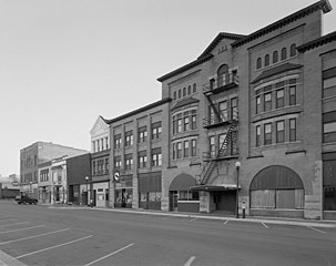
English: Buildings in the Crookston Commercial Historic District in central Crookston, Polk County, Minnesota, United States. The district reflects the city's early period of growth, which was prompted by agriculture and the railroad industry. It remains a large, and mostly intact, concentration of late nineteenth- and early twentieth-century commercial structures and is listed on the National Register of Historic Places. |
|||||
| Терахь | Хууш доцу терахь | |||||
| Хьост | Library of Congress Prints and Photographs Division, Historic American Buildings Survey: MINN,60-CROK,1-6 | |||||
| Автор | Анонимный автор | |||||
| Бакъонаш (Йуха хӀара файл лелор) |
|

| Местоположение объекта | | Это и другие изображения по их местоположению на OpenStreetMap |
|---|

|
Это изображение из Библиотеки Конгресса США, отдел эстампов и фотографий (Prints and Photographs division), имеет цифровой идентификатор (digital ID) hhh.mn0444.
Этот шаблон не указывает на правовой статус данной работы. По-прежнему необходим нормальный шаблон лицензий. См. Commons:Лицензирование.
|
Файлан истори
Тlетаlаде терахь/хан, муха хилла хьажарна и файл.
| Терахь/Хан | Жима | Файлан барам | Декъашхо | Билгалдаккхар | |
|---|---|---|---|---|---|
| карара | 2009, 31 январь, 14:07 | | 956 × 757 (84 Кб) | Cropbot | upload cropped version, operated by User:Finavon. Summary: border cropped |
| 2009, 29 январь, 14:35 |  | 1024 × 818 (96 Кб) | Nyttend | {{Information |Description=Photograph from the {{w|Historic American Buildings Survey}} of buildings in the {{w|Crookston Commercial Historic District}}, an area listed on the {{w|National Register of Historic Places}}. The district is located in central |
Файл лелор
ХӀара файл лахарчу 1 агӀонгахь лелош йу:
Глобалан файл лелор
ХӀара файл лелош йу лахахь гайтина йолу википедеш чохь:
- Лелор ar.wikipedia.org
- Лелор arz.wikipedia.org
- Лелор azb.wikipedia.org
- Лелор be.wikipedia.org
- Лелор ca.wikipedia.org
- Лелор ceb.wikipedia.org
- Лелор dag.wikipedia.org
- Лелор de.wikipedia.org
- Лелор en.wikipedia.org
- Лелор en.wikivoyage.org
- Лелор es.wikipedia.org
- Лелор eu.wikipedia.org
- Лелор fa.wikipedia.org
- Лелор fr.wikipedia.org
- Лелор ht.wikipedia.org
- Лелор hu.wikipedia.org
- Лелор ia.wikipedia.org
- Лелор ko.wikipedia.org
- Лелор ky.wikipedia.org
- Лелор lld.wikipedia.org
- Лелор pt.wikipedia.org
- Лелор ru.wikipedia.org
- Лелор sh.wikipedia.org
- Лелор sr.wikipedia.org
- Лелор tr.wikipedia.org
- Лелор tt.wikipedia.org
- Лелор uk.wikipedia.org
- Лелор ur.wikipedia.org
- Лелор uz.wikipedia.org
- Лелор vi.wikipedia.org
- Лелор www.wikidata.org
- Лелор zh-min-nan.wikipedia.org